Bhu Naksha AP is an official portal launched by the government of Andhra Pradesh to provide digital access to Cadastral Maps and Field Measurement Books (FMB). These tools are essential for property owners, farmers, and other stakeholders who need precise details about land boundaries, plot divisions, and ownership information.
Through the Bhu Naksha AP portal, users can easily view, download, and print maps of their land without having to visit government offices. The portal offers transparency and convenience, making land-related data accessible to anyone with an internet connection.
Key Features of Bhu Naksha AP
- Cadastral Maps: Provides a detailed visual representation of land parcels, helping users identify property boundaries, plot numbers, and neighboring land areas.
- Field Measurement Book (FMB): Access accurate land measurement data for each plot. This is crucial for land transactions, property disputes, and legal documentation.
- Land Records Access: By entering basic details such as the District, Village, Zone, and Survey Number, users can access comprehensive land records, including ownership and usage information.
- Village Maps: Offers detailed maps at the village level, allowing users to explore and verify specific plots within their locality.
- Survey Number Search: Enables users to search for land by Plot (Survey) Number, ensuring easy access to specific land parcels.
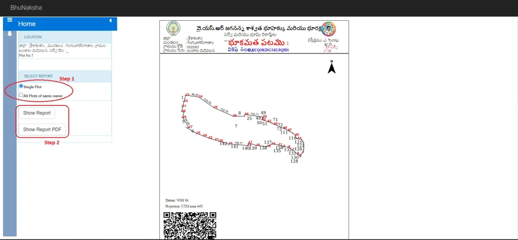
- Map Report Generation: Users can generate and download reports for a single plot or for all plots under the same ownership. The portal provides the option to download the reports in PDF format, which can be printed for official use.
Benefits of Bhu Naksha AP
- Convenience: No need to visit local revenue offices to access land records and maps.
- Transparency: The online platform ensures transparency in land ownership details and boundaries.
- Accuracy: Access to detailed FMB ensures that all measurements and land data are accurate.
- Legal Use: The reports generated can be used for legal purposes, property transactions, and land disputes.
The Bhu Naksha AP portal is a significant step towards digitizing land records in Andhra Pradesh, making it easier for citizens to access important land-related information with just a few clicks.
Andhra Pradesh Bhu Naksha AP (Cadastral Map)
To check the Cadastral Map of your land in Andhra Pradesh, follow these steps on the official Bhu Naksha AP website:
- Visit the Portal: Go to the official Bhu Naksha AP website.
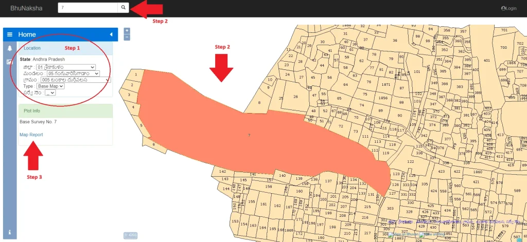
- Select Land Details: Choose your District, Zone, Village, and Land Type, and enter your Survey Number.
- View the Map: Based on the details provided, the map will appear on your screen.
- Select Your Plot: Use the map or search bar to locate your plot by Plot (Survey) Number. Once selected, your Plot Information will be displayed.

- Generate Map Report: Click the Map Report button and select whether you want the report for a Single Plot or All Plots of the Same Owner.
- Download/Print: Click the Show Report PDF button to view the report. You can then download or print the Village Map or Cadastral Map as needed.
